- info@gokturkharita.com
- iptv satın al

Göktürk Group Harita
Mimarsinan Mah. Abdülhamithan Caddesi (İstanbul Cad.) Ata Sk. No:13/A Kemerburgaz-Eyüp / İSTANBUL
+90 (212) 360 19 09
info@gokturkharita.com
+90 (212) 360 19 09
Contact Us Now
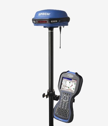
EPOCH 50 Spectra Precision GPS (RTK)
EPOCH 50 Spectra Precision GPS (RTK)
Survey Pro, Fast Survey and Survey Office software provides all the support you need for sensitive field work, including cadastral work, ground control and construction applications.
Product Features
Cadastral works Survey Pro, Fast Survey and Survey Office software
Sensitive terrain jobs, including ground control and construction applications
EPOCH 50 Spectra Precision GPS (RTK)
● 220 channel GNSS device
● Multiple satellite (GPS+GLONASS+GALILEO+BEIDOU+SBAS)
● Rugged and wireless design
● Ability of RTK, Static and PPK suerveying
● TUSAGA active compatibility with network RTK feature
● İnternal receiver - transmitter 1W radio modem
● Bluetooth transfer options
● Ability to work in Any weather situation
● Long life battery
● SP Survey Pro professional terrain software
The Spectra Precision EPOCH 50 GNSS receiver enables the use of GPS L1 / L2 / L2C / L5, GLONASS L1 / L2 and BeiDou B1 / B2 signals for working with all satellite systems in its 220 channels. The EPOCH 50 GNSS receiver uses its proven cutting-edge technology in tracking new and powerful L2C and L5 signals as well as in determining an extremely stable phase center.
The combination of all these signals, multi-satellite support and receiving data processing power provide precise and reliable results.
Receiver / transmitter UHF radio
The Epoch50 GNSS receiver has a radio modem with built-in receiver and transmitter in one. Use an internal radio on your company site for easy and simple setup. With external batteries, you can continue your work all day. EPOCH50 GNSS device supports external radio and GPRS modem with its flexible structure and long range suitable add-ons. All Bluetooth® enabled receivers can wirelessly communicate with all world-class Spectra Precision controllers.
Proven Technology
EPOCH 50 GNSS device, with initial reliability of 99.9%, provides fast and high quality results in many surveying modes including RTK, Post-Process kinematics and static modes. With consistent and precise results, quality construction work and affordable prices, the EPOCH 50 GNSS device is the ideal choice for you to get the necessary efficiency on your project.
Survey Pro terrain software
The key to getting the best results from your devices is the terrain software you are using. Spectra Precision Survey Pro ™ terrain software is well suited to work with your EPOCH 50 GNSS like other Spectra Precision products. You can choose one of 4 different manuel control units and activate Survey Pro software and use it in your projects. Survey Pro software is easy to use: when combined with the power of the EPOCH 50 GNSS device, you can complete your project in a short time.
Manage Your Data
Spectra Precision Survey Ofice software provides a precise solution in the Post-Process processing of your GNSS and terrain surveying data. Transfer all processed and completed results directly with on-site or office software sets using different formats.
Mobile Network Capability
The EPOCH 50 GNSS receiver supports many real-time GNSS reference networks installed around the world. Real-time network: It eliminates the need to install fixed stations and so reduces costs and increases efficiency. With the network process and GSM / GPRS backup supported by Survey Pro terrain software, Spectra Precision hand controllers provide you with the best quality, correction data regardless of any location.
Maximum Performance
Survey Pro terrain software EPOCH 50 GNSS device and accessories provide the power you need to complete your project. You can count on EPOCH 50 GNSS device with its proven technology that reduces your workforce with maximum sensitivity, quality and easy using. By pairing Spectra Precision with the advanced and durable hand control units, you can achieve maximum efficiency and reliability in your terrain project.


